Skip to content

In the footsteps of seafarers

Kokkola National Urban Park comprises nearly 20,000 hectares. It is Finland’s largest national urban park. The majority of the surface area is water.  Our maritime cultural heritage is one of the unique characteristics of Kokkola National Urban Park.  The sea has played an integral role in the town’s evolution. At first, it was used for fishing and seal hunting. Later the sea served as a channel for international trade. Kokkola’s merchant fleet was one of the largest in Finland in its time. For a long time, tar-making, shipbuilding and related trade activities were the bread and butter of the city. Sea traffic turned Kokkola into an international and prosperous port town, absorbing influences from overseas.

Seagoing has not always been easy. The seas in front of Kokkola hide many wrecks and stories of fateful journeys. As the city became wealthier and trade grew, various types of beacons such as head lights, lighthouses and pilot stations were built to keep ships safe. They made navigation easier and enabled ships to travel in and out of the port year round. Nevertheless, the harsh coastal waters still claimed many ships.

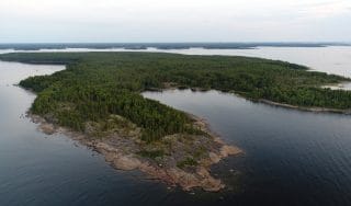
  • Tankar island and lighthouse in the outer archipelago is part of Kokkola National Urban Park. The rugged island emerged from the sea during the 1200s as a result of land uplift and became a landmark for seafarers. Because of land uplift, the island is continuously expanding and its vegetation changes.

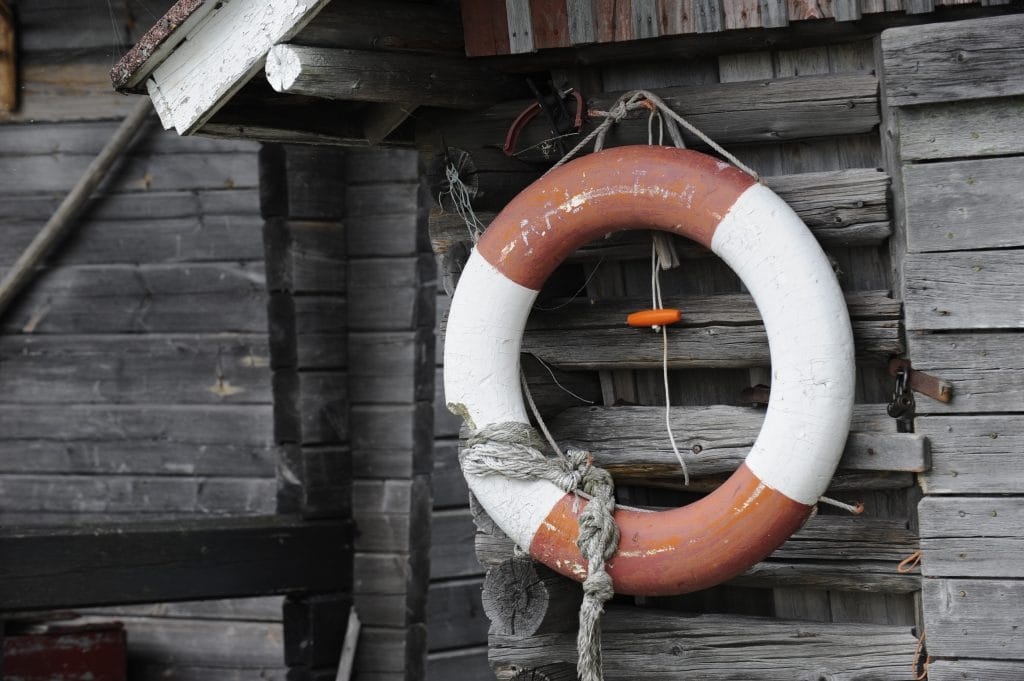
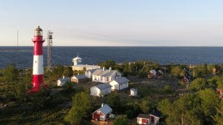
    For centuries, Tankar has provided shelter for fishermen and seal hunters. The existing lighthouse was completed in 1889, and it is still the brightest lighthouse in Finland. Vibrant communities have created a unique building stock and a charming fishing village around the island’s sheltered harbour. The village buildings include a small red church built in 1754. The buildings form a nationally significant built cultural environment. Tankar continues to be a traditional summer holiday destination for many coastal residents, and many of the fishermen’s cottages are still owned by the same families.

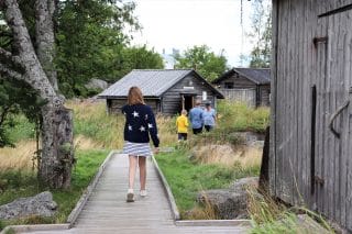
    Duckboard trails and diverse vegetation make the island a great destination for ramblers. Some 260 bird species have been spotted on the island. The north cliffs and the southern and western shores of the island are the most important breeding grounds for birds. You could even spot a white-tailed eagle, Finland’s largest bird species by wingspan. In summer, visitors can count on meeting sheep that graze on the island.

    Explore Tankar

    Tankar is a versatile tourist destination that offers unforgettable nature experiences and glimpses of old-time island life. Tankar is part of the Natura 2000 nature conservation programme, and its beautiful ruggedness belies its fragile nature. Visitors must keep to marked trails and paths.

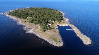
    Tankar is great for day trips, but an overnight stay allows you to fully experience the island atmosphere. Overnight guests are treated to the magical sight of the lighthouse beacon out on the silent water. You can stay at Tankar Inn at the pilot station, or at the village guesthouse. During the day, visit the seal-hunting museum to explore the ancient livelihood of these shores. The lighthouse site and outbuildings take you on a journey through time and the lives of station pilots, lighthouse keepers and their families.

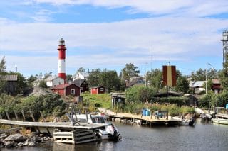
    You can arrive by your own boat or jump on board the M/S Jenny. The island has a guest marina with 15 spaces. M/S Jenny operates regularly during the summer period between Tankar and Kokkola Meripuisto Park. The summer café, barbecue spots and the guest marina serve visitors and island-dwellers alike.

  • Poroluoto sheds light on the earliest stages of the region’s story. It transports visitors to a time when the main livelihoods of the town’s people were agriculture, fishing and seal-hunting. Islands like Poroluoto were used as bases by fishermen and seal hunters. There are interesting trails and signs of the region’s maritime cultural history. Keen-eyed hikers can spot remains of ancient fire pits and hut bottoms. The campsites were temporary shelters built with stones by fishermen. The roof was covered with materials such as sail canvas weighed down with oars to keep dry overnight. At the tip of Poroluoto there are piles of rocks, where traps that were used to catch Baltic herring were laid out to dry. At the southern end of the island, there is a wave breaker built by Russian prisoners of war. Old forests on Poroluoto were destroyed by fire in the 1940s, which is why the current tree stock consists of fairly uniform, pine-dominated mixed stands that are approximately 60 years old. There are also fens and forested wetlands on the island. Poroluoto has the highest point in the Kokkola archipelago. The point emerged from the sea around 1,600–1,700 years ago.

    Poroluoto is a popular boating and hiking destination. It is the largest of the islands just outside Kokkola.  The landing site is in the back of the bay behind the wavebreaker. Landing can be difficult in northerly winds. In winter, you can get to Poroluoto on cross-country skis, depending on ice and snow conditions.

    At the northern end of the island there is a wilderness hut, and the island also has a sauna, a toilet, a campfire site and an information board. Most of Poroluoto is in a nature conservation area and the island is part of the Kokkola archipelago Natura 2000 site.

  • Poroluodonkari, or Krunni, is a rocky pine-forested island that is approximately 700 metres long. This ancient fishermen’s base was first mentioned in the 1550s as a Baltic herring catch site used by people from Kälviä. Six boat groups were said to have fished off the island at that time. Fishing activity peaked in the late 1800s, when Krunni served as a base for 30 different boat groups. Most of the buildings on Krunni are former fishermen’s cabins. The oldest cabins were on the eastern shore, where some of the foundations are still visible. As a result of land uplift, during the 1700s and 1800s the fishermen built mostly on the western shore. The oldest of the surviving cabins probably dates from the early 1900s. More recent buildings are located in the southern tip, where there is a harbour built by the state in the 1970s.

    Finland’s oldest beacon

    The rocky and increasingly shallow coast necessitated the construction of lighthouses, head lights and daymarks, which tell their own stories of the coast’s history. One of the oldest seamarks in Kokkola National Urban Park is on Krunni. Located at the northern end of the island, Lyysi of Krunni dates from the 1700s and is Finland’s oldest fishermen’s beacon. The beacon is a small hexagonal wooden building standing on a shallow stone footing. It has a shingle roof and a narrow beacon tower, which used to be lit to guide fishermen. At the northern end of the island, there is also an example of a stone maze known as jatulintarha, “giant’s run”. There are many stories about the history of these mazes, and it is still unclear why people used to build them.

    Today, Krunni is a popular boating and hiking destination. There are also some privately owned summer cottages. The sheltered harbour is at the southern end of the island. There is an information board in the harbour, and a hut for hikers on the western side of the island. Web cameras record the weather conditions on Krunni every 15 minutes, and you can check them online. The Krunni weather webcam is available at http://krunni.com/.

    Krunni is part of the Kokkola archipelago Natura 2000 site. In summer, sheep graze on the island, doing their bit for conservation. Pets must be kept on a leash on the island. People must stay away from the rocks and coastal meadows on the northern side during the bird nesting season from 1 May until 31 July. In addition, the Defence Forces occasionally carries out training with ammunition in the area, and any restrictions must be observed.

  • Out in the sea, the cultural history of Kokkola National Urban Park can be found under water. The underwater world hides hundreds of shipwrecks and a seafarers’ cemetery.

    The front of Kokkola is dotted with islands and rocky outcrops. Due to land uplift, the coast becomes shallower year by year, cutting off some of the old navigation routes. Sea ice and high storms also move boulders and rocks around.

    The treacherous coast and challenging conditions have claimed many lives. The oldest records of shipwrecks predate the city itself. In 2015, a ship trap which has claimed hundreds of vessels was found off the coast near Tankar. There are shipwrecks all over the waters of Kokkola National Urban Park, but the concentration around Tankar seems to be the biggest. Ships sank both on the mainland side of the island and further out in the archipelago. Due to land uplift and the shifting coastline, wrecks are sometimes found on land.